Collection Items
-
 MapKarte von Kleinasien
Karte von Kleinasien in 24 Blatt Relief shown by hachures and spot heights. Shows Turkey and small areas of northern Syria and Iraq. Title from sheets. German. Place names in Turkish. Some place name also in German and/or Latin. LC copy includes two second editions of sheet BII (1912 and 1914) and third editions of sheets AIV (1914), AV (1915), BV (1915), and DIV (1911). LC copy imperfect: lacking sheet…- Contributor: Kiepert, Richard
- Date: 1908-01-01
- Resource: Image - 29
-
 MapBirds-eye view from summit of Mt. Washington, White Mountains, New-Hampshire Coloration differs from other ed.--purple predominates. Indexed for points of interest. Available also through the Library of Congress Web site as a raster image.
- Contributor: Geo. H. Walker & Co
- Date: 1908-01-01
- Resource: Image
-
 MapBirds-eye view from summit of Mt. Washington, White Mountains, New-Hampshire Coloration differs from other ed.--blue predominates. Indexed for points of interest. Available also through the Library of Congress Web site as a raster image.
- Contributor: Geo. H. Walker & Co
- Date: 1908-01-01
- Resource: Image
-
 MapMap of Arverne : 1908 Cadastral map showing lot lines/numbers, house numbers, and buildings (some named). "Copyrighted 1908 by Lewis H. May Co., N.Y.C." Includes notes. Available also through the Library of Congress Web site as a raster image.
- Contributor: Lewis H. May Co - Von Hardenberg Co
- Date: 1908-01-01
- Resource: Image
-
 MapRoutt Co., Colorado : present boundaries of precincts in red ink, figures in purple, vote pulled in 1908, Nov. 3. vcFY24 Black, red, and purple ink on printed base ruled for "congressional" townships and sections. Area includes present [1958] Routt and Moffat Counties. Annotated in red and black ink: Present boundaries of precincts in red ink, figures in purple = vote pulled in 1908--Nov. 3. Stamped in black on verso: Colorado Office copy. Stamped in red on verso: 2967. "Tr. Census Jan 1958"--On previous…
- Contributor: United States. Bureau of the Census
- Date: 1908
- Resource: Image
-
 Collection[Maps of California--various subjects Forests, misc., Kf-Lz]
Alternate supplied title: California title collection drawer 19 | Alternate supplied title: California title collection--various subjects Forests, misc., Kf-Lz This record covers single maps of California covering various individual parks and reserves, which are not represented in the LC database by separate catalog records. This collection includes single printed maps and photocopies of printed or manuscript single maps as well as some multi-sheet single maps, and may also include plates from atlases, books or periodicals, and printed facsimiles. To request a specific map…- Date: 1908-01-01
-
 Collection[Maps of California--various subjects Forests, misc., Ma-Mn]
Alternate supplied title: California title collection drawer 20 | Alternate supplied title: California title collection--various subjects Forests, misc., Ma-Mn This record covers single maps of California covering various individual parks and reserves, which are not represented in the LC database by separate catalog records. This collection includes single printed maps and photocopies of printed or manuscript single maps as well as some multi-sheet single maps, and may also include plates from atlases, books or periodicals, and printed facsimiles. To request a specific map…- Date: 1908-01-01
-
 MapMap of Napa & Solano Counties Cal.
Map of Napa and Solano Counties, Cal Blue line; county borders hand colored. Shows roads, railways, towns, drainage, township and range, and ranchos. Available also through the Library of Congress Web site as a raster image.- Contributor: Punnett Brothers
- Date: 1908-01-01
- Resource: Image
-
 Collection[Maps of Alaska, 1908-1915]
Alternate supplied title: Alaska title collection--drawer 6 | Alternate supplied title: Alaska title collection--general 1908-1915 This record covers single general maps of Alaska, which are not represented in the LC database by separate catalog records. This collection includes single printed maps and photocopies of printed or manuscript single maps and may also include some multi-sheet single maps, plates from atlases, books or periodicals, and printed facsimiles. To request a specific map or for more information, contact a reference librarian…- Date: 1908-01-01
-
 MapSurveys of the Panama Canal Relief shown by form lines and spot heights. Geographic coverage complete in three sheets. LC copy imperfect: missing Map no. 1. Sectioned in eight and mounted on cloth. Available also through the Library of Congress Web site as a raster image.
- Contributor: Goethals, George W. (George Washington) - Isthmian Canal Commission (U.S.)
- Date: 1908
-
 MapMap of Gorgona showing area in which the commission has authorized the licensing of saloons : scale 1:2000, December 1980 Transferred from the collection of the Canal Zone Library-Museum, 1979. Pen-and-ink. "Area shown colored yellow. Present saloons shown colored red." Indexed for saloons. Canal Zone Library map checklist number: 234. Available also through the Library of Congress Web site as a raster image. Imperfect: Not colored and small sections missing. Vault
- Contributor: Isthmian Canal Commission (U.S.). Office of Chief Engineer
- Date: 1908
- Resource: Image
-
 MapMappa geral da Republica dos Estados Unidos do Brasil. Available also through the Library of Congress web site as a raster image.
- Contributor: Calmon, Miguel - Companhia Lithographica Hartmann-Reichenbach
- Date: 1908-01-01
- Resource: Copy 1 - Image
-
 MapZhaotong Fu yu tu.
昭通府與圖 | Map of Zhaotong Prefecture Scale ca. 1:20,000. Relief shown pictorially. Pictorial map. Shows garrison troops, garrison posts, roads connecting various stations in walled city of Zhaotong Fu, Yunnan Province. Hummel purchase 1930, no. 27. Available also through the Library of Congress Web site as a raster image. Previous call number: G7822.Z4A5 1820 .Z4 Vault AACR2- Contributor: Hummel, Arthur W. (Arthur William)
- Date: 1908-01-01
- Resource: Image
-
 MapMap of the Philippine Islands
Philippine Islands Relief shown by shading, hachures, and spot heights. "Copyright, 1908, by Caspar W. Hodgson." Available also through the Library of Congress Web site as a raster image. Gift: S.W. Boggs. Insets: Babuyan Islands -- Shibutu I.- Contributor: Briesemeister, A. - A. Hoen & Co - World Book Company (Yonkers, N.Y.) - Hodgson, Caspar W.
- Date: 1908-01-01
- Resource: Image
-
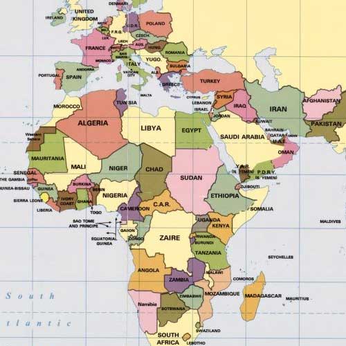
 Map[Africa]. Shows European colonies and independent countries in Africa ca. 1908. Differs from other manuscript, G8200 1908 .W41, in coloration. In lower left corner: The Wells Missionary Map Co., 3612 Prairie Avenue, Chicago, copyright applied for. Cloth map. Pen-and-ink, pencil, crayon, and watercolor; place names, names in legend, and coordinates mechanically drawn in black ink. "I." Available also through the Library of Congress Web site…
- Contributor: Wells Missionary Map Co
- Date: 1908-01-01
- Resource: Image
-
 Map[Africa]. Shows European colonies and independent countries in Africa ca. 1908. Differs from other manuscript. G8200 1908 .W4, in coloration. In lower left corner: The Wells Missionary Map Co., 3612 Prairie Avenue, Chicago, copyright applied for. Cloth map. Pen-and-ink, pencil, crayon, and watercolor; place names, names in legend, and coordinates mechanically drawn in black ink. "I." Available also through the Library of Congress Web site…
- Contributor: Wells Missionary Map Co
- Date: 1908-01-01
- Resource: Image
-
 Map[Comparative area map of Africa] Shows the continent of Africa in relationship to the land area of U.S. and Alaska, British North America, Mexico, and Europe. In lower left corner: The Wells Missionary Map Co., 3612 Prairie Avenue, Chicago, copyright applied for. Cloth map. Pen-and-ink, pencil, crayon, and watercolor; place names mechanically drawn in black ink. "II." Available also through the Library of Congress Web site as a raster…
- Contributor: Wells Missionary Map Co
- Date: 1908
- Resource: Image
-
 Map[Railroad map of Africa]. Cloth map. Relief shown pictorially. Title supplied by cataloger. In lower left corner: "The Wells Missionary Map Co., 3612 Prairie Avenue, Chicago." Pen-and-ink, pencil, crayon, and watercolor; place names mechanically printed in black ink. In upper right corner: "III." Available also through the Library of Congress Web site as a raster image.
- Contributor: Wells Missionary Map Co
- Date: 1908-01-01
- Resource: Image
-
 MapGospel temperance railroad map. Relief shown pictorially. "Copyright 1908, by G. E. Bula." In lower left corner: GEB 2-'08. Includes notes. Available also through the Library of Congress Web site as a raster image.
- Contributor: Bula, G. E.
- Date: 1908-01-01
- Resource: Copy 1 - Image
-
 CollectionGeneral Maps This category includes maps that typically portray the physical environment and a variety of cultural elements for a geographic area at a particular point in time. The maps in this category show a geographic area larger than a city or town and do not display a subject that is part of one of the thematic categories.
- Date: 1290
Collection Items: View 6,869 Items