Collection Items
-
 MapWildwood Lake Park, Riverhead, Township of Southhampton, Suffolk County, N.Y. Available also through the Library of Congress web site as a raster image.
- Contributor: Seaside Villa Homes Co
- Date: 1903
- Resource: Copy 1 - Image
-
 MapDover, New Jersey 1903. Perspective map not drawn to scale. Bird's-eye-view. LC Panoramic maps (2nd ed.), 511 Available also through the Library of Congress Web site as a raster image. Includes illus. and index to points of interest. Vault AACR2: 110; 651/1
- Contributor: Fowler & Bailey
- Date: 1903-01-01
- Resource: Image
-
 MapOcean City, N.J. : showing its unrivalled location, beautiful sea-shore, protected sailing waters, and famous fishing grounds, also railroads and ferry connections, artesian water, sanitary sewage [sic], electric lights, gas, electric cars. Class G. XXc. no. 4920 U.S. Copyright Office Bird's-eye view to horizon. Oriented with north toward the upper right. Available also through the Library of Congress Web site as a raster image. LC copy halved and mounted on cloth backing.
- Contributor: Taylor, Frank H. (Frank Hamilton)
- Date: 1903-01-01
- Resource: Image
-
 MapView of Duncannon, Pennsylvania 1903 Perspective map not drawn to scale. Bird's-eye-view. LC Panoramic maps (2nd ed.), 765 Available also through the Library of Congress Web site as a raster image. Includes ill. and index to points of interest. Vault AACR2: 100; 651/1
- Contributor: Fowler, T. M. (Thaddeus Mortimer)
- Date: 1903-01-01
- Resource: Image
-
 MapMechanicsburg, Pa., 1903. Perspective map not drawn to scale. Bird's-eye-view. LC Panoramic maps (2nd ed.), 802.3 Available also through the Library of Congress Web site as a raster image. Includes illus. and index to points of interest. AACR2
- Contributor: Fowler, T. M. (Thaddeus Mortimer)
- Date: 1903-01-01
- Resource: Image
-
 MapView of Newville, Cumberland Co., Pennsylvania 1903 Perspective map not drawn to scale. Bird's-eye-view. LC Panoramic maps (2nd ed.), 818 Available also through the Library of Congress Web site as a raster image. Includes illus. and index to points of interest. Vault AACR2: 100; 651/1
- Contributor: Fowler, T. M. (Thaddeus Mortimer)
- Date: 1903-01-01
- Resource: Image
-
 MapStrasburg, Lancaster Co., Pa. 1903 Perspective map not drawn to scale. Bird's-eye-view. LC Panoramic maps (2nd ed.), 854 Available also through the Library of Congress Web site as a raster image. Includes ill. and index to points of interest. Vault AACR2: 100; 651/1
- Contributor: Fowler, T. M. (Thaddeus Mortimer)
- Date: 1903-01-01
- Resource: Image
-
 MapView of Wellsville, Pennsylvania 1903 Includes illustrations. Available also through the Library of Congress Web site as a raster image.
- Contributor: Fowler, T. M. (Thaddeus Mortimer)
- Date: 1903
- Resource: Image
-
 MapBird's eye view looking northwest, city of Anniston, Calhoun County, Alabama. Perspective map not drawn to scale. Indexed for points of interest. LC Panoramic maps (2nd ed.), 3 Available also through the Library of Congress Web site as a raster image. AACR2
- Contributor: Dry, Camille N. - Hart, Chas. (Charles)
- Date: 1903-01-01
- Resource: Image
-
 MapOlympia, the capital on Puget Sound, Washington. LC Panoramic maps (2nd ed.), 971 Available also through the Library of Congress Web site as a raster image. Includes illus. AACR2: 651/1
- Contributor: Franklin Engraving & Electrotyping Co - Lange, Edward
- Date: 1903-01-01
- Resource: Image
-
 MapMain business district periscopic Seattle. Perspective map not drawn to scale. Bird's-eye-view. LC Panoramic maps (2nd ed.), 976 Available also through the Library of Congress Web site as a raster image. AACR2: 651/1; 650/2
- Contributor: Tulloch, Ross W. - Periscopic Map Co
- Date: 1903-01-01
- Resource: Image
-
 MapBird's eye view of Pasadena and vicinity. Perspective map not drawn to scale. Map of Pasadena, "Copyright 1903, by W. W. Benedict and W. S. Woodworth," and indexes on verso. LC Panoramic maps (2nd ed.), 30.2 Available also through the Library of Congress Web site as a raster image. AACR2
- Date: 1903-01-01
- Resource: recto - Image
-
 MapPort Arthur. Title supplied by cataloger. LC copy: In lower margin, name of photographer (illegible). Sheet sectioned to 4 panels to enable folding when not in use. Annotated in pencil on verso: Port Arthur before Japanese war. "A. Dunecer"--On folder. Available also through the Library of Congress Web site as a raster image.
- Date: 1903-01-01
- Resource: Image
-
 CollectionPanoramic Maps The panoramic map was a popular cartographic form used to depict U.S. and Canadian cities and towns during the late nineteenth and early twentieth centuries. Known also as bird's-eye views, perspective maps, and aero views, panoramic maps are nonphotographic representations of cities portrayed as if viewed from above at an oblique angle. Although not generally drawn to scale, they show street patterns, individual buildings,…
- Contributor: Hébert, John R. - Library of Congress. Geography and Map Division - Dempsey, Patrick E. (Patrick Eugene)
- Date: 1997
Collection Items: View 1,523 Items
-
 Article
 -
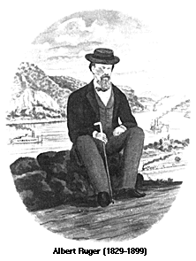 ArticlePanoramic Artists and Publishers The Library of Congress, Geography and Map Division holds panoramic maps done by Albert Ruger, Thaddeus Mortimer Fowler, Lucien R. Burleigh, Henry Wellge, and Oakley H. Bailey who were among the most prolific and successful panoramic map artists. Such well known print makers as Currier & Ives also made panoramic maps. Although this was not a leading panoramic mapmaking firm, this company's distinctive views…
- Date: 1829
-
 ArticleTopographical Survey of St. Louis Missouri Select a numbered tile to view a detailed panoramic map
- Date: 1847