Collection Items
-
 MapFolded bird's-eye view of Bennington, VT. : showing all points of interest.
Bennington, VT Bird's-eye view. Relief shown pictorially. Title from cover. Includes indexes to points of interest. Imperfect: Darkened, brittle, creased, torn, small pieces missing. Available also through the Library of Congress Web site as a raster image. PM3 Acquisitions control no.: 2006-138- Contributor: Burleigh, L. R. (Lucien R.)
- Date: 1905-01-01
- Resource: Image
-
 MapBoston and environs. Perspective map not drawn to scale. Bird's-eye view. Oriented with north to the right. LC Panoramic maps (2nd ed.), 280.1 Available also through the Library of Congress Web site as a raster image. AACR2
- Contributor: Geo. H. Walker & Co
- Date: 1905-01-01
- Resource: Image
-
 MapTwentieth century Boston. Perspective map not drawn to scale. Bird's-eye-view. LC Panoramic maps (2nd ed.), 280 Available also through the Library of Congress Web site as a raster image. AACR2: 100; 651/1
- Contributor: Poole, A. F. - A.W. Elson & Co - F. D. Nichols Company
- Date: 1905-01-01
- Resource: Image
-
 MapBird's-eye view of Branford, Connecticut. Relief shown pictorially. Includes ill. of buildings and index to points of interest. Copy imperfect: Torn along edges. Available also through the Library of Congress Web site as a raster image. PM3 Acquisitions control no.: 2007-208
- Contributor: Hughes & Bailey
- Date: 1905-01-01
- Resource: Image
-
 MapBird's eye view of Wallingford, Connecticut. Perspective map not drawn to scale. LC Panoramic maps (2nd ed.), 98.2 Available also through the Library of Congress Web site as a raster image. Includes illus., index to points of interest, and view "Wallingford in 1852." AACR2
- Contributor: Hughes & Bailey
- Date: 1905-01-01
- Resource: Image
-
 MapAtlantic City, N.J. Perspective map not drawn to scale. Bird's-eye-view. LC Panoramic maps (2nd ed.), 506 Available also through the Library of Congress Web site as a raster image. AACR2: 651
- Contributor: National Publishing Co
- Date: 1905-01-01
- Resource: Image
-
 MapBerlin, Somerset County, Pennsylvania 1905 Perspective map not drawn to scale. Bird's-eye-view. LC Panoramic maps (2nd ed.), 737 Available also through the Library of Congress Web site as a raster image. Includes illus. and index to points of interest. Vault AACR2: 100; 651/1
- Contributor: Fowler, T. M. (Thaddeus Mortimer)
- Date: 1905-01-01
- Resource: Image
-
 MapConfluence, Pennsylvania 1905 Perspective map not drawn to scale. Bird's-eye-view. LC Panoramic maps (2nd ed.), 756 Available also through the Library of Congress Web site as a raster image. Includes ill. Vault AACR2: 100; 651/1
- Contributor: Fowler, T. M. (Thaddeus Mortimer)
- Date: 1905-01-01
- Resource: Image
-
 MapBird's-eye view of Everett, Bedford County, Pa., 1905. Perspective map not drawn to scale. LC Panoramic maps (2nd ed.), 775 Available also through the Library of Congress Web site as a raster image. Includes illus. AACR2: 100
- Contributor: Fowler, T. M. (Thaddeus Mortimer)
- Date: 1905-01-01
- Resource: Image
-
 MapView of Frostburg, Maryland 1905 Perspective map not drawn to scale. Bird's-eye-view. LC Panoramic maps (2nd ed.), 259 Available also through the Library of Congress Web site as a raster image. Includes ill. Vault AACR2: 100; 651/1
- Contributor: Fowler, T. M. (Thaddeus Mortimer)
- Date: 1905-01-01
- Resource: Image
-
 MapLonaconing, Maryland
Lonaconing, Maryland, 1905 Aerial view of small town. Relief shown by landform drawings. Available also through the Library of Congress Web site as a raster image. Purchase; FY '13 Philip Lee Phillips Society purchase; July 2013. Includes illustrations of prominent buildings.- Contributor: Philip Lee Phillips Society - Fowler, T. M. (Thaddeus Mortimer) - Fowler & Kelly
- Date: 1905-01-01
- Resource: Image
-
 MapMidland, Maryland Aerial view of village. Relief shown by shading and landform drawings. Purchase; FY '13 Philip Lee Phillips Society purchase; July 2013. Includes inset view of "Ocean" village and illustrations of prominent buildings. Available also through the Library of Congress Web site as a raster image.
- Contributor: Fowler, T. M. (Thaddeus Mortimer) - Philip Lee Phillips Society
- Date: 1905-01-01
- Resource: Image
-
 MapView of Parsons, West Virginia 1905. Perspective map not drawn to scale. Bird's-eye-view. LC Panoramic maps (2nd ed.), 1006 Available also through the Library of Congress Web site as a raster image. Includes illus. AACR2
- Contributor: Fowler, T. M. (Thaddeus Mortimer) - Fowler & Kelly
- Date: 1905-01-01
- Resource: Image
-
 MapPanoramic view of Omaha. Perspective map not drawn to scale. Bird's-eye-view. LC Panoramic maps (2nd ed.), 468 "Supplement to the Omaha Daily Bee, January 1, 1906." Available also through the Library of Congress Web site as a raster image. AACR2: 651
- Contributor: Austen, Edward J. - Bee Publishing Company, Jefferson, IA
- Date: 1905-01-01
- Resource: Image
-
 MapSpokane, Washington. Perspective map not drawn to scale. Bird's-eye-view. LC Panoramic maps (2nd ed.), 978 Available also through the Library of Congress Web site as a raster image. Includes index to points of interest and inset "Fort Wright." AACR2
- Contributor: John W. Graham & Co. (Spokane, Wash.)
- Date: 1905-01-01
- Resource: Image
-
 MapCapital city of Oregon, Salem. Perspective map not drawn to scale. Bird's-eye-view. LC Panoramic maps (2nd ed.), 726 Available also through the Library of Congress Web site as a raster image. Includes illus. AACR2: 651/1
- Contributor: Koppe, E. - Mutual L. And Lith Co - Fromm, Ch
- Date: 1905-01-01
- Resource: Image
-
 MapBird's-eye view of San Pedro, Cal. Available also through the Library of Congress Web site as a raster image. Includes ill. of "Bank of San Pedro." LC copy annotated in black ink to show ownership and property available for purchase. PM3
- Date: 1905-01-01
- Resource: Image
-
 Map[San Mateo Park. Perspective map not drawn to scale. Bird's-eye view. LC Panoramic maps (2nd ed.), 44 Available also through the Library of Congress Web site as a raster image. AACR2: 650/2
- Contributor: Bull, William H. - Baldwin & Howell
- Date: 1905-01-01
- Resource: Image
-
 Photo, Print, DrawingThe city of greater New York Bird's-eye view of greater New York with Battery Park on the right and showing the boroughs of Bronx, Queens, Manhattan, Brooklyn, and Richmond, with the Hudson River in the foreground; prominent features and locations are listed below image.
- Date: 1905-01-01
- Resource: raster image - Image
-
 CollectionPanoramic Maps The panoramic map was a popular cartographic form used to depict U.S. and Canadian cities and towns during the late nineteenth and early twentieth centuries. Known also as bird's-eye views, perspective maps, and aero views, panoramic maps are nonphotographic representations of cities portrayed as if viewed from above at an oblique angle. Although not generally drawn to scale, they show street patterns, individual buildings,…
- Contributor: Dempsey, Patrick E. (Patrick Eugene) - Library of Congress. Geography and Map Division - Hébert, John R.
- Date: 1997
Collection Items: View 1,523 Items
-
 Article
 -
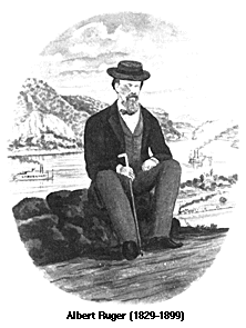 ArticlePanoramic Artists and Publishers The Library of Congress, Geography and Map Division holds panoramic maps done by Albert Ruger, Thaddeus Mortimer Fowler, Lucien R. Burleigh, Henry Wellge, and Oakley H. Bailey who were among the most prolific and successful panoramic map artists. Such well known print makers as Currier & Ives also made panoramic maps. Although this was not a leading panoramic mapmaking firm, this company's distinctive views…
- Date: 1829
-
 ArticleTopographical Survey of St. Louis Missouri Select a numbered tile to view a detailed panoramic map
- Date: 1847