Collection Items
-
 MapAero view of Willimantic, Connecticut 1909. Perspective map not drawn to scale. Bird's-eye-view. LC Panoramic maps (2nd ed.), 103 Available also through the Library of Congress Web site as a raster image. Includes illus., index to points of interest, and directory. AACR2
- Contributor: Bailey, O. H. (Oakley Hoopes) - Hughes & Bailey
- Date: 1909-01-01
- Resource: Image
-
 MapAero view of Freeport, Long Island, N.Y. 1909. Perspective map not drawn to scale. Bird's-eye-view. LC Panoramic maps (2nd ed.), 565 Available also through the Library of Congress Web site as a raster image. Includes illus. and directory. AACR2
- Contributor: Hughes & Bailey
- Date: 1909-01-01
- Resource: Image
-
 Map1909 Pawling, N.Y. Perspective map not drawn to scale. Bird's-eye view. LC Panoramic maps (2nd ed.), 613 Available also through the Library of Congress Web site as a raster image. Indexed for points of interest. AACR2: 651
- Contributor: Smith, P. H. - Knickerbocker Litho. Co - Tice, W. G.
- Date: 1909-01-01
- Resource: Image
-
 MapAero view of Atlantic City, New Jersey 1909. Perspective map not drawn to scale. Bird's-eye-view. LC Panoramic maps (2nd ed.), 508 Available also through the Library of Congress Web site as a raster image. Includes illus. and index to points of interest. AACR2
- Contributor: Hughes & Bailey
- Date: 1909-01-01
- Resource: Image
-
 MapBirds eye view of Garfield, New Jersey 1909 Perspective map not drawn to scale. LC Panoramic maps (2nd ed.), 515 Available also through the Library of Congress Web site as a raster image. Includes ill. Vault AACR2: 100; 651/1
- Contributor: Fowler, T. M. (Thaddeus Mortimer)
- Date: 1909-01-01
- Resource: Image
-
 MapBirdseye view of Erie, Penna. 1909. Perspective map not drawn to scale. LC Panoramic maps (2nd ed.), 773 Available also through the Library of Congress Web site as a raster image. AACR2: 651/1
- Contributor: Lederle (Chas.) & Co - Lederle, Charles
- Date: 1909-01-01
- Resource: Image
-
 MapBird's-eye-view of Colorado Springs, Colorado. Perspective map not drawn to scale. Oriented with north to the right. LC Panoramic maps (2nd ed.) 59 Indexed for points of interest. Available also through the Library of Congress Web site as a raster image. AACR2
- Contributor: Benford-Bryan Pub. Co
- Date: 1909-01-01
- Resource: Image
-

-
 MapLos Angeles, 1909 Bird's-eye view. Relief shown pictorially. Shows Los Angeles city and vicinity. LC copy mounted on cloth backing. Includes index to points of interest. Imperfect: Stained, darkened, small portions of sheet torn along edge. Available also through the Library of Congress Web site as a raster image. PM3 Acquisitions control no.: 2006-001
- Contributor: Birdseye View Publishing Co
- Date: 1909-01-01
- Resource: Image
-
 MapLos Angeles 1909. Perspective map not drawn to scale. Bird's-eye-view. On verso: City and suburban street map of Los Angeles. Accompanied by index. 24 p. LC Panoramic maps (2nd ed.), 29 Available also through the Library of Congress Web site as a raster image. AACR2: 651/1; 651/2
- Contributor: Western Litho. Co - Birdseye View Publishing Co - Gates, Worthington
- Date: 1909-01-01
-
 CollectionPanoramic Maps The panoramic map was a popular cartographic form used to depict U.S. and Canadian cities and towns during the late nineteenth and early twentieth centuries. Known also as bird's-eye views, perspective maps, and aero views, panoramic maps are nonphotographic representations of cities portrayed as if viewed from above at an oblique angle. Although not generally drawn to scale, they show street patterns, individual buildings,…
- Contributor: Dempsey, Patrick E. (Patrick Eugene) - Hébert, John R. - Library of Congress. Geography and Map Division
- Date: 1997
Collection Items: View 1,523 Items
-
 Article
 -
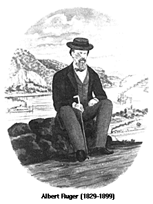 ArticlePanoramic Artists and Publishers The Library of Congress, Geography and Map Division holds panoramic maps done by Albert Ruger, Thaddeus Mortimer Fowler, Lucien R. Burleigh, Henry Wellge, and Oakley H. Bailey who were among the most prolific and successful panoramic map artists. Such well known print makers as Currier & Ives also made panoramic maps. Although this was not a leading panoramic mapmaking firm, this company's distinctive views…
- Date: 1829
-
 ArticleTopographical Survey of St. Louis Missouri Select a numbered tile to view a detailed panoramic map
- Date: 1847