
Drag your mouse over the map to see the map before and after treatment
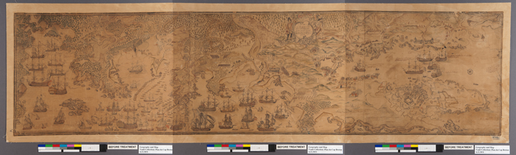
The Plan du Cap Breton, dit Louisbovrg avec ces environs pries, commemorates the 1758 siege of Louisbourg (Nova Scotia, Canada) during the 1754-1763 war between France and Britain known as the Seven Years’ War or, the French and Indian War. The hand-drawn large panorama map (79” x 21”) depicts the seizure and encampment of New France, which included Cape Breton Island, by the British Navy. With the siege, the British successfully wrested control of Cape Breton and its fishing industries and set the stage for Britain’s advances on North America. Historians generally agree that this marked the turning of the tide of success in Britain’s favor, ultimately leading Britain to victory and dominance in North America.
The Library of Congress acquired the map in 1903 and likely treated it soon thereafter by cutting the map into three panels, adhering each third onto paper, then adhering the three pieces onto a single piece of cloth (from the back) and a single piece of thin silk gauze (from the front) with gaps in between each third to permit folding for storage.
Over time, the silk and adhesives discolored and darkened to the extent that the map was barely legible, leading the Library's curators and conservators to decide to treat the map again about one hundred years later.